
Warren County Genealogical Society
Warren County, Ohio
Chapter of Ohio Genealogical Society
Map Links

(513) 695-1144
![]()
406 Justice Drive, Lebanon, Ohio 45036
Hours: 9 AM-4 PM Monday through Friday
Driving Directions
![]()
|
|
Warren County Genealogical Society |
|
|
(513) 695-1144
|
|
wcgs@co.warren.oh.us |
|
|
||
|
|
|
|
|
|
|
This page contains links to maps of Warren County. We have access to
many other maps not listed here available in our library. Feel free to stop by
and see what else we have. For those researchers unable to come in but who would
like a copy of a specific map, please contact our
research department.
| GIS Maps | Warren County Map Links | Cemetery Maps |
Property Search from Auditor's Office |
| Map Room | Land Records | Road Name Changes | WCGS Maps |
Locating Other Warren County Maps
Beers
History
1867 Map
1875 Maps
Township Formation
Combined Atlas
Warren County Area Map
GIS
Cemetery Maps
Highway Maps
Warren County Gen Web Maps
Franklin Public Library
USGS Topographical Maps
Sanborn Fire Insurance Maps
1932 Plats
Repositories
![]()
Beers History of Warren County, Chapter 3 – Explorations, Surveys, Land Grants. There is a whole section devoted to the description of land in Warren County mentioned in Beers History on the following pages: 223-233. There are no maps of the county, but there are extensive details on how the land was platted and laid out.
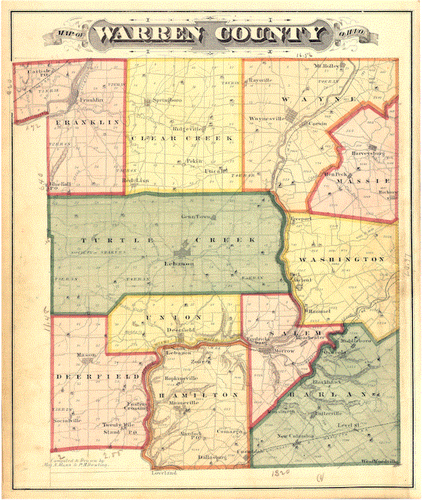
1867 Wall Map of Warren County Original copies of this map are on display at the Warren County Historical Society and at the Warren County Record Center and Archives. A "nearly" full scale black and white reproduction of the map can be purchased from the Warren County G.I.S. department for $12.00. The Warren County Genealogical society has color reproductions of the map (in sections) available for viewing in their library. The Title block reads as follows "Map of Warren Co Ohio from actual Surveys by G. P. Sanford, J. Silliman Higgins & R. H. Harrison, Civil Engineers; A. Warner Publisher; Philadelphia, 1867". Arne Trelvik has completed an every name index to these maps. Digital images have been loaded online to the Warren County US GenWeb page. http://www.rootsweb.ancestry.com/~ohwarren/maps/1867map.htm
Warren County Township Formation Maps by Tom Foley
Prior to 1803, what is now Warren County was in Deerfield Township of Hamilton County. This series of handy maps drawn by Tom Foley is available on the WCGS Website at http://www.co.warren.oh.us/genealogy/twp_map.htm The maps show both the changes in the county boundaries and the transition from 4 townships in 1803 to the 11 townships that we have today. (1803, 1804, 1806, 1813/1815, 1818, 1850, 1860)
In 1998, The Warren County Historical Society sponsored the publication of "Combined Atlases of Warren County, Ohio 1875 - 1891 - 1903; Wall Map 1856; 1854 & 1888 Maps of Lebanon" Copies are available from the Warren County Historical Society. [It was $49 but check with the society at for current price with shipping]. This black and white reproduction contains the following (descriptions from title pages of the individual items). The society has added "every name" indexes for the text portions of the 1875 and 1903 atlases.
|
1856 |
Map of Warren Co. Ohio from actual survey by P. O'Beirne C.E.; Anthony D. Byles Publisher; No. 17 & 19 Minor St., Philadelphia; 1856
|
|
Combination Atlas Map of Warren county Ohio compiled, drawn and published from personal examinations and survey by L. H. Everts; 1875. The Warren County Genealogical Society has an image of the County Level map from the atlas on line
|
|
|
1891 |
Complete Atlas of Warren County, Ohio
containing maps of the county and of each of its townships and villages,
from official records and actual surveys, with Descriptive, Historical and
Statistical Matter by Frank A. Bone, Civil Engineer and late County
Surveyor, in connection with The Rand-McNally & Co's New Standard Atlas of
the World; Lebanon, Ohio: published by Frank A. Bone. 1891 |
|
The
Centennial Atlas of Warren County, Ohio
Containing Complete Maps of the County and each of its townships and
Villages, carefully Platted from Official Records and Recent Surveys;
together with A General History of the County from the Time of the
Earliest Explorations of White Men to the Present, showing the Progress
and Achievements of its first Century; compiled and written by Will S.
McKay, Editor of The Western Star; also Half-tone Illustrations of Public
Buildings, Residences and Business Houses, Portraits and Biographies of
well-known People, Names of living U. S. Soldiers of all Wars, List of
Members of Lodges and Fraternal Orders, Etc., Etc.; photos by C. M.
Huffman and J. J. G. Steddom; E. S. Rhodes, solicitor; Lebanon, Ohio, The
Centennial Atlas Association, Publishers, 1903 |
|
|
Map of Warren County by vintage World Atlas |
|
|
1854 |
Map
of Lebanon |
|
1888 |
Map of Lebanon, Warren County, Ohio surveyed and published by P. O'Beirne Civil Engineer & Surveyor; Jersey City N.J. |
Clickable Warren County, Ohio Area Map by township with links to surrounding county GenWeb sites.
GIS Township Maps STR & VMD: Clearcreek, Deerfield, Franklin, Hamilton, Harlan, Massie, Salem, Turtlecreek, Union, Washington, Wayne
Cemetery Maps arranged by Township: Clearcreek, Deerfield, Franklin, Hamilton, Harlan, Massie, Salem, Turtlecreek, Union, Washington, Wayne
Ohio Department of Transportation Highway Map of Warren County
Maps at Warren County US Gen Web
The Franklin Public Library also has some Warren County topographical maps at the island reference desk in the same cabinet as their microfilms.
Historic USGS Topographic Maps are on line courtesy of maptech.com which can be accessed at http://historical.maptech.com/index.cfm. The index for the Ohio portion of the collection can be found at http://historical.maptech.com/quadlist.cfm?stateabr=OH The online versions of these maps are divided into quarters. We are fortunate that all of Warren County is included in the collection, spread over all or part of the following map images. These maps help to locate early district schools by name, particularly on the Morrow Quadrangle plus show the location of the many railroad and traction lines located in the county at that time.
The following are available:
1906 Mason Quadrangle NE Quarter
1906 Mason Quadrangle SE Quarter
1907 Blanchester Quadrangle NW Quarter
1907 Blanchester Quadrangle SW Quarter
1908 Miamisburg Quadrangle SE Quarter
1915 Waynesville Quadrangle SW Quarter
1915 Waynesville Quadrangle SE Quarter
1916 Mason Quadrangle NW Quarter
1916 Mason Quadrangle NE Quarter
1916 Mason Quadrangle SW Quarter
1916 Mason Quadrangle SE Quarter
1917 Xenia Quadrangle SW Quarter
Sanborn Fire Insurance Maps are available on line courtesy of the Ohio Public Library Information Network [OPLIN] through their online databases at http://search3.webfeat.org.oh0231.oplin.org/oplinsearch.html. You will need a library card number. The following is a list of the Warren County locations available in the database.
|
Location |
Date |
# of Records |
|
Franklin |
1885 July |
4 |
|
|
1892 May |
6 |
|
|
1898 March |
7 |
|
|
1916 December |
10 |
|
|
1926 September |
26 |
|
|
|
|
|
Lebanon |
1885 March |
2 |
|
|
1890 October |
3 |
|
|
1895 June |
5 |
|
|
1901 September |
5 |
|
|
1907 April |
9 |
|
|
1917 January |
12 |
|
|
1923 June |
14 |
|
|
1923 June - 1941 February |
14 |
|
|
|
|
|
Mason |
1898 March |
1 |
|
|
1911 September |
2 |
|
|
1946 February |
6 |
|
|
|
|
|
Morrow |
1895 June |
3 |
|
|
1901 September |
3 |
|
|
1919 March |
8 |
|
|
|
|
|
Waynesville |
1895 July |
2 |
|
|
1901 August |
3 |
|
|
1925 April |
10 |
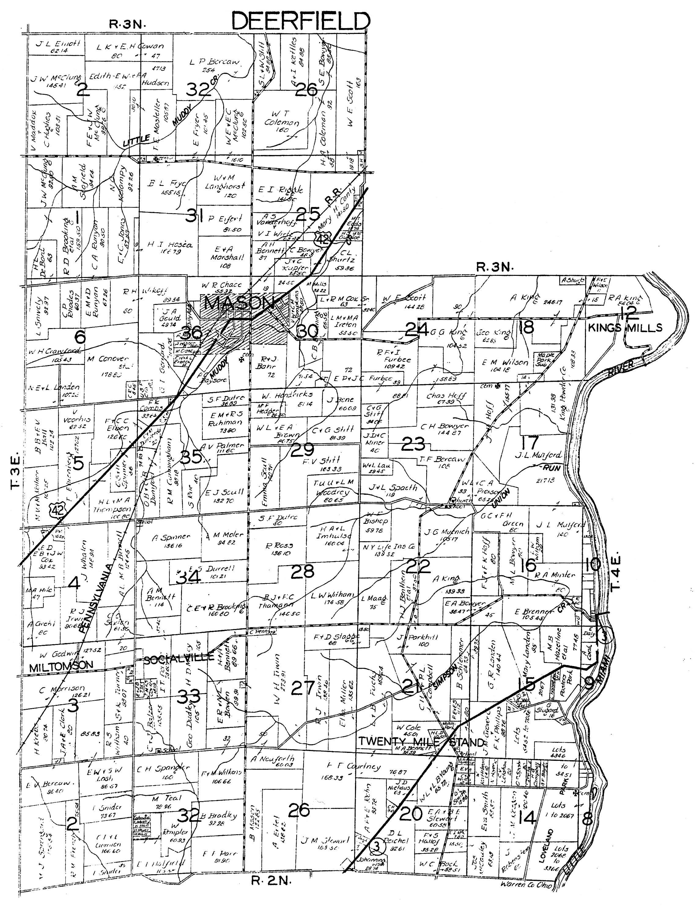
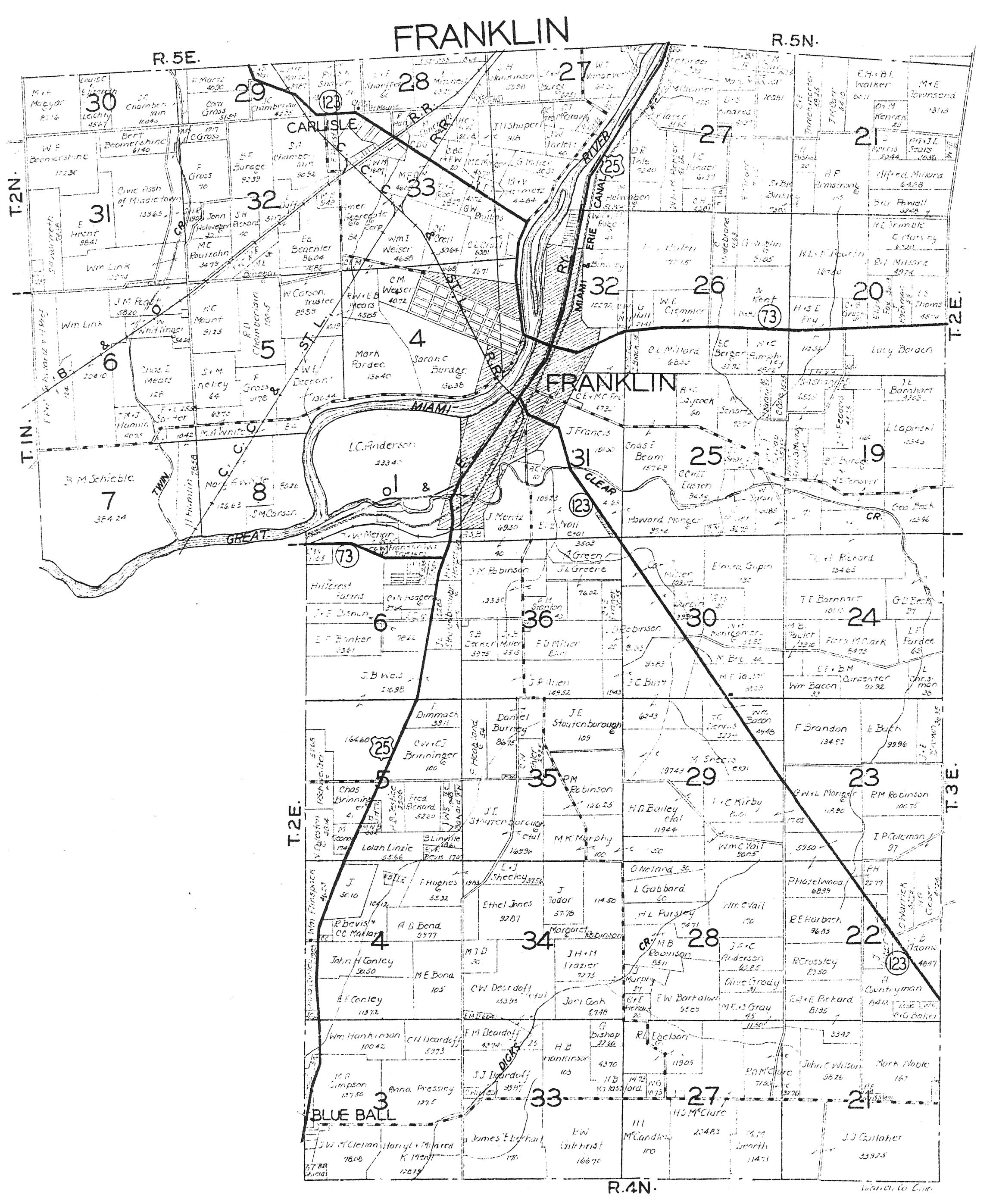
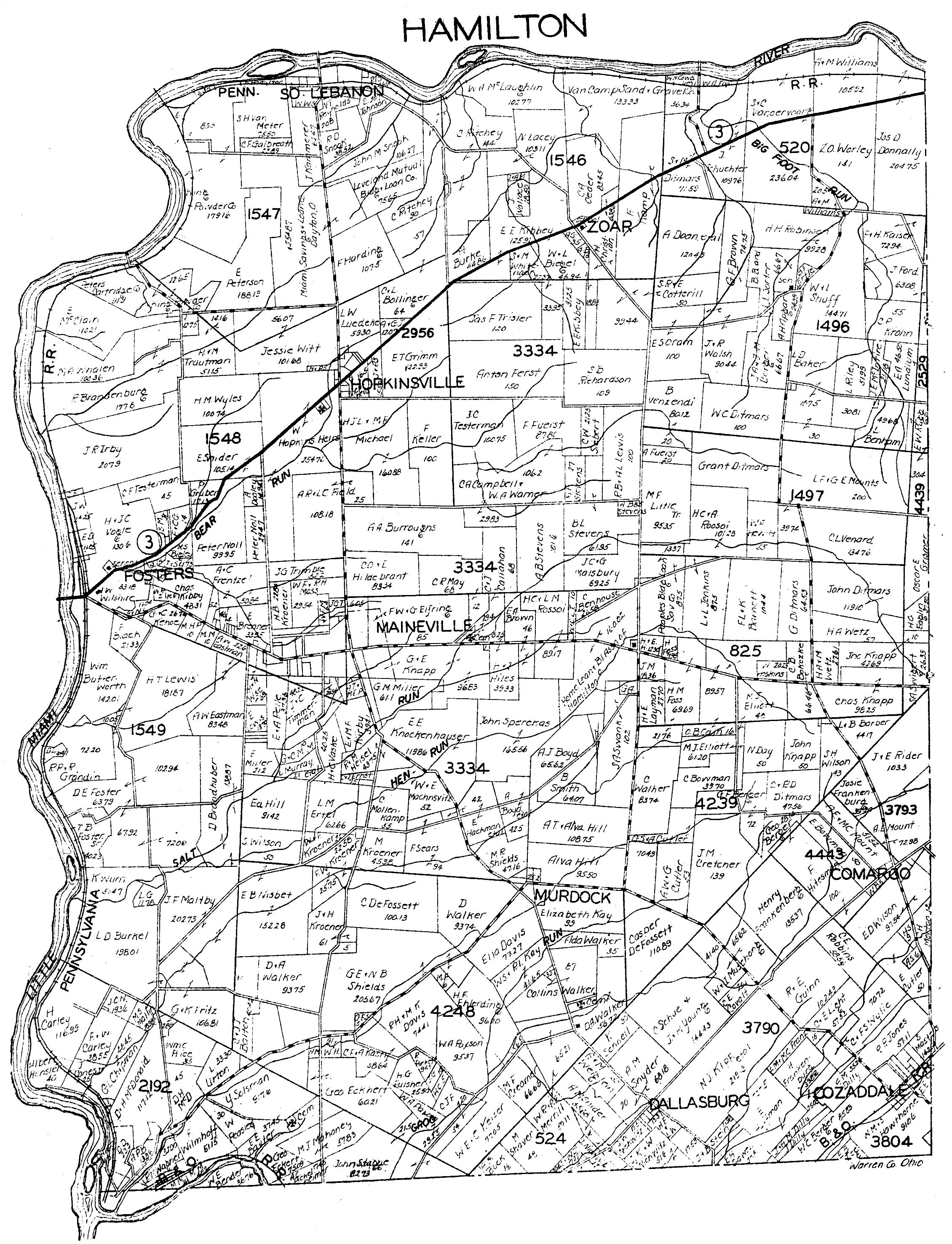
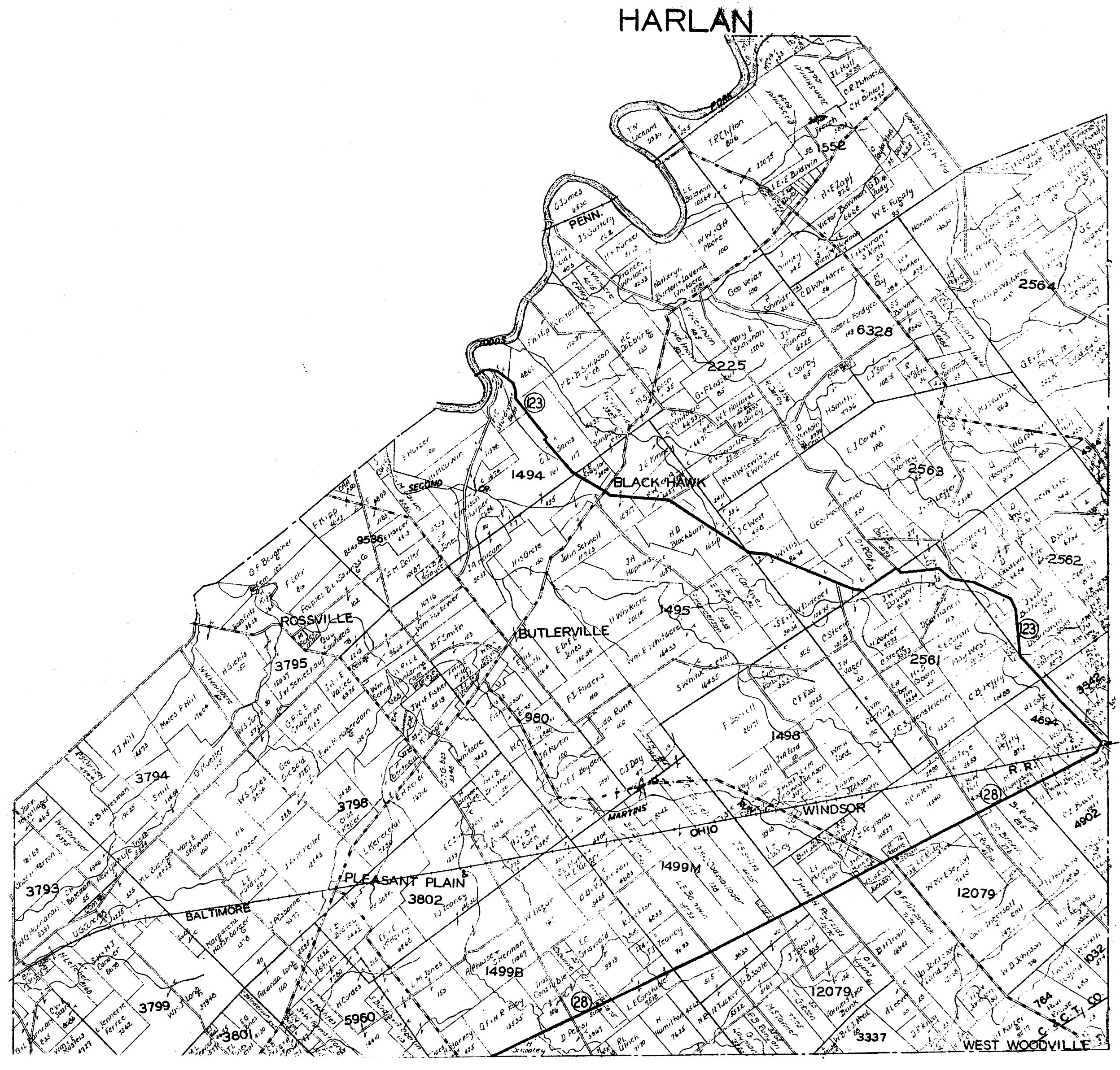
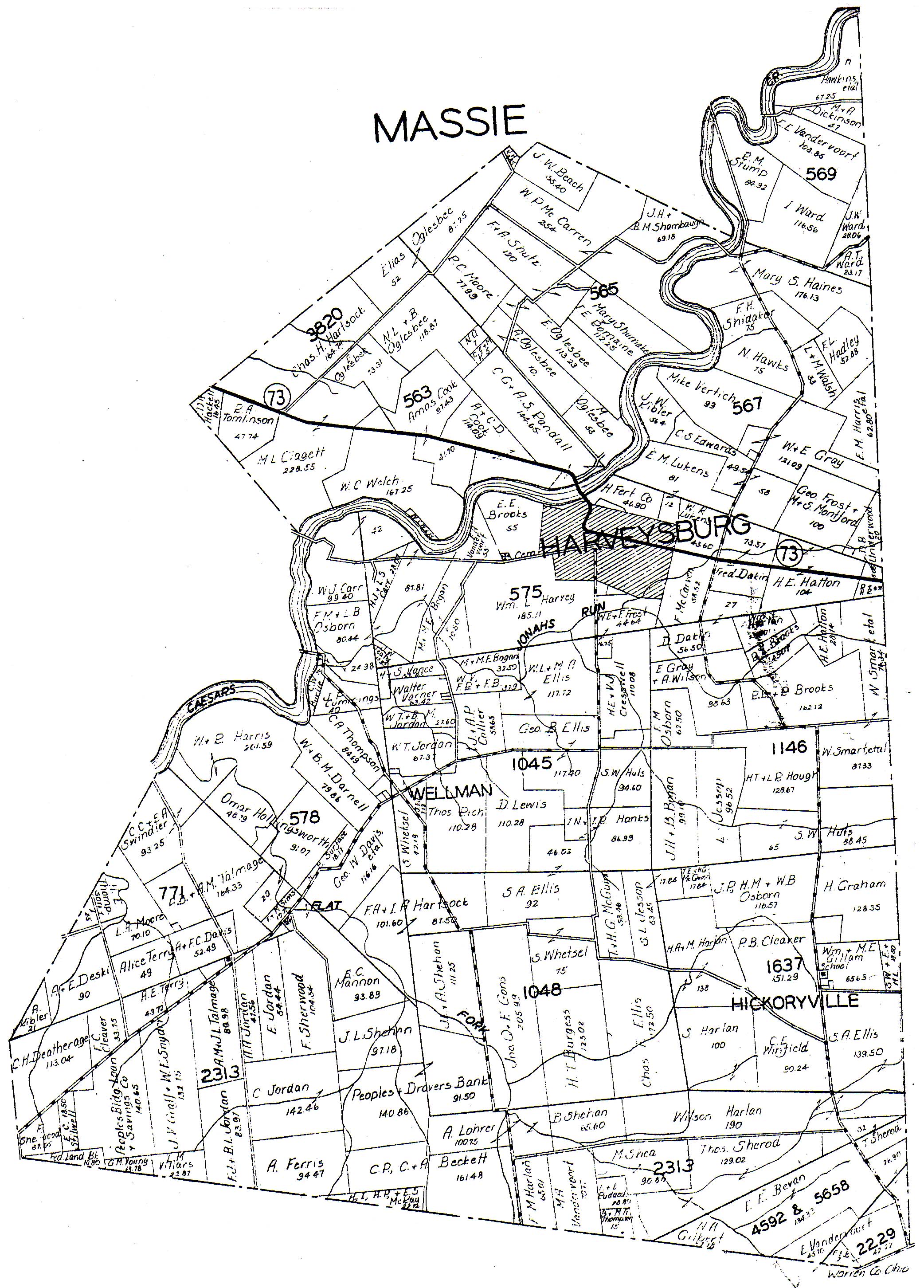
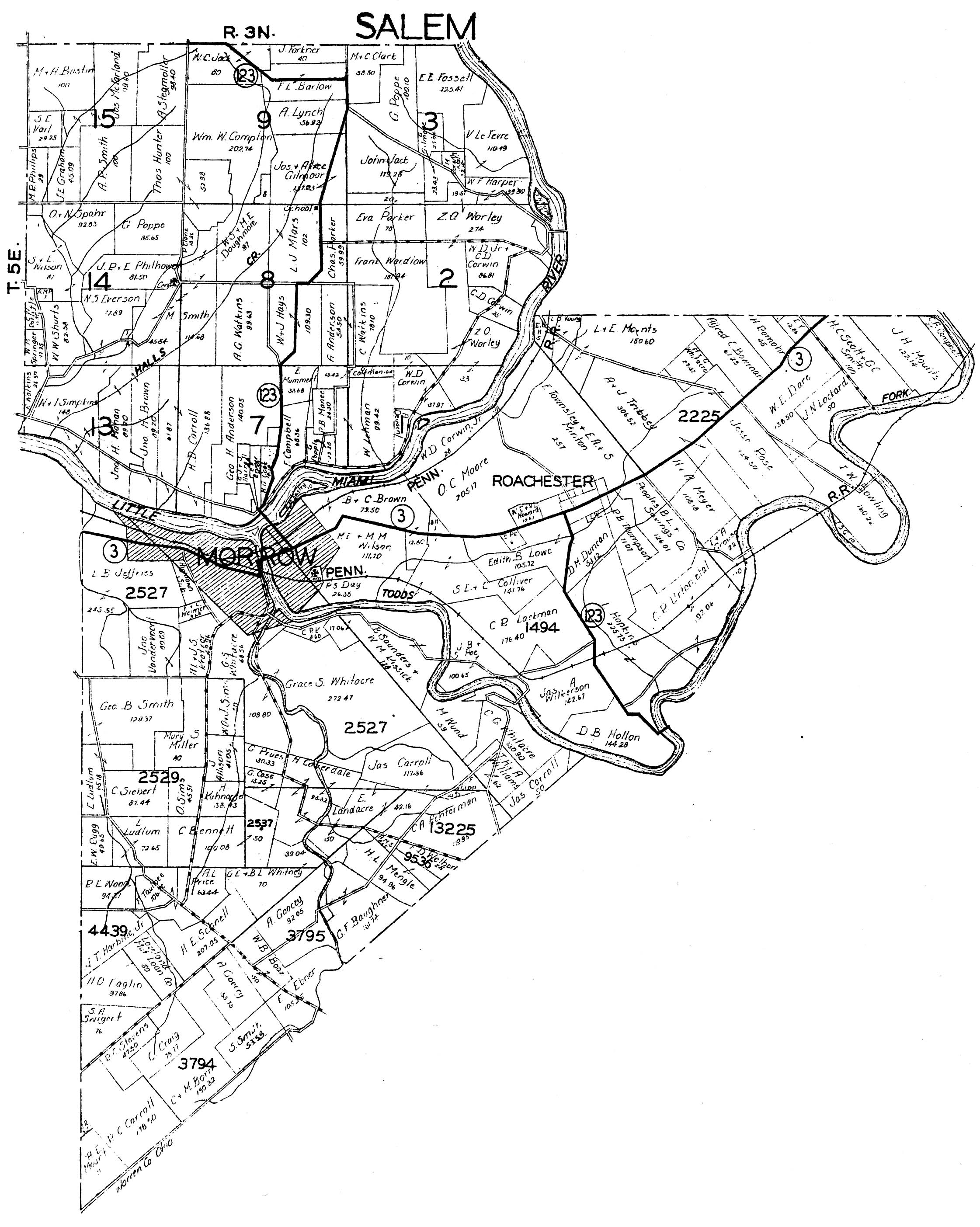
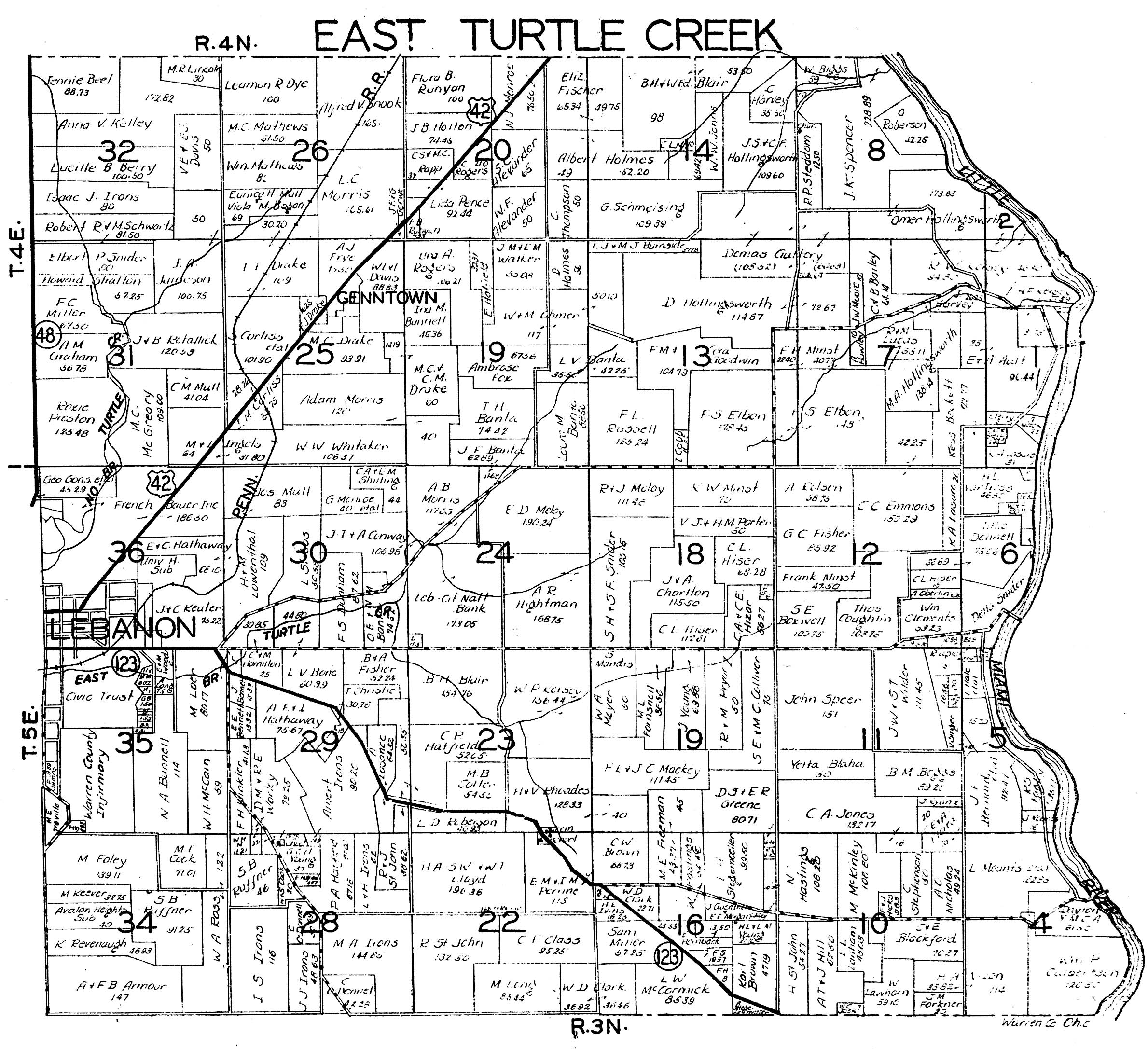
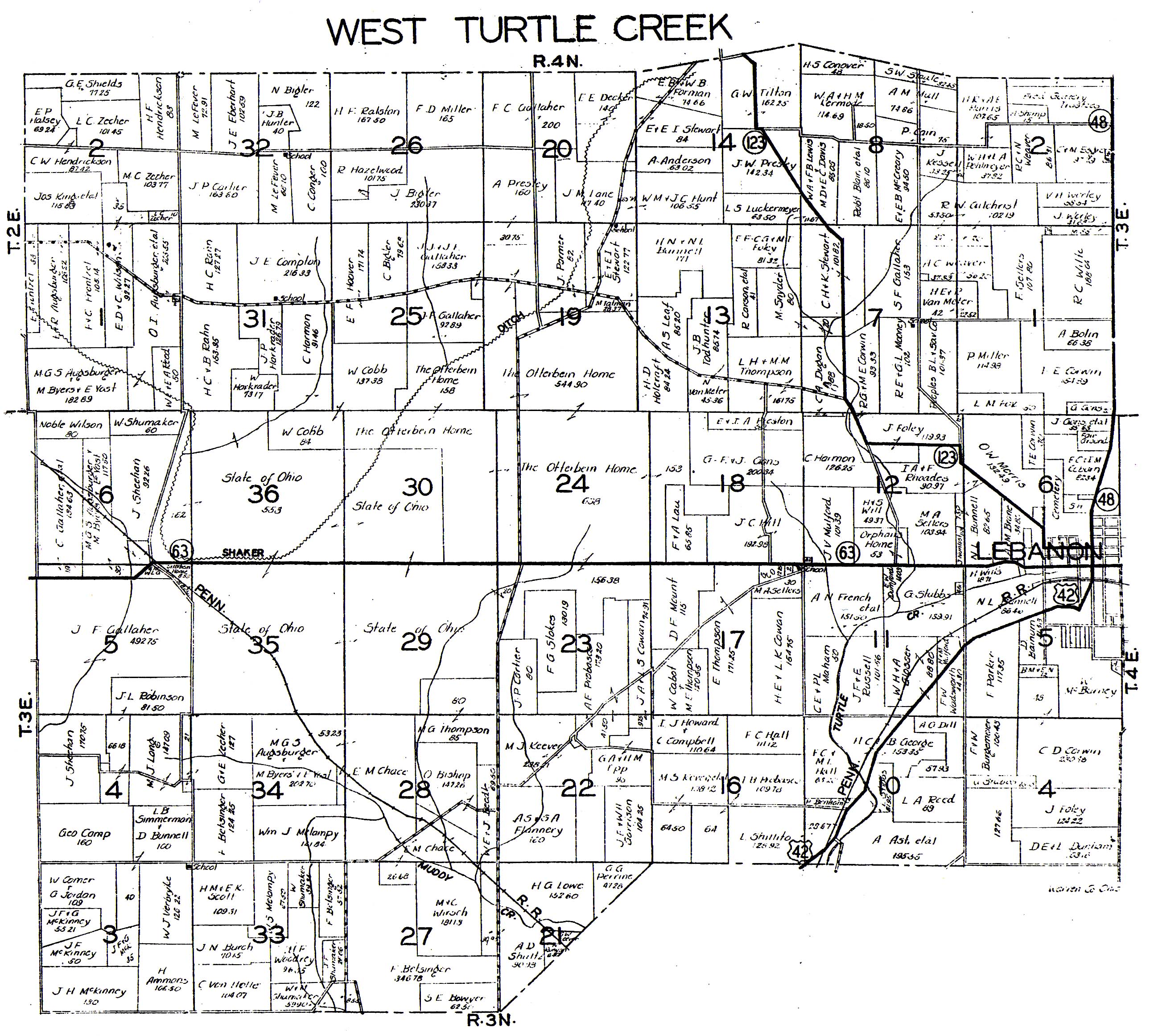
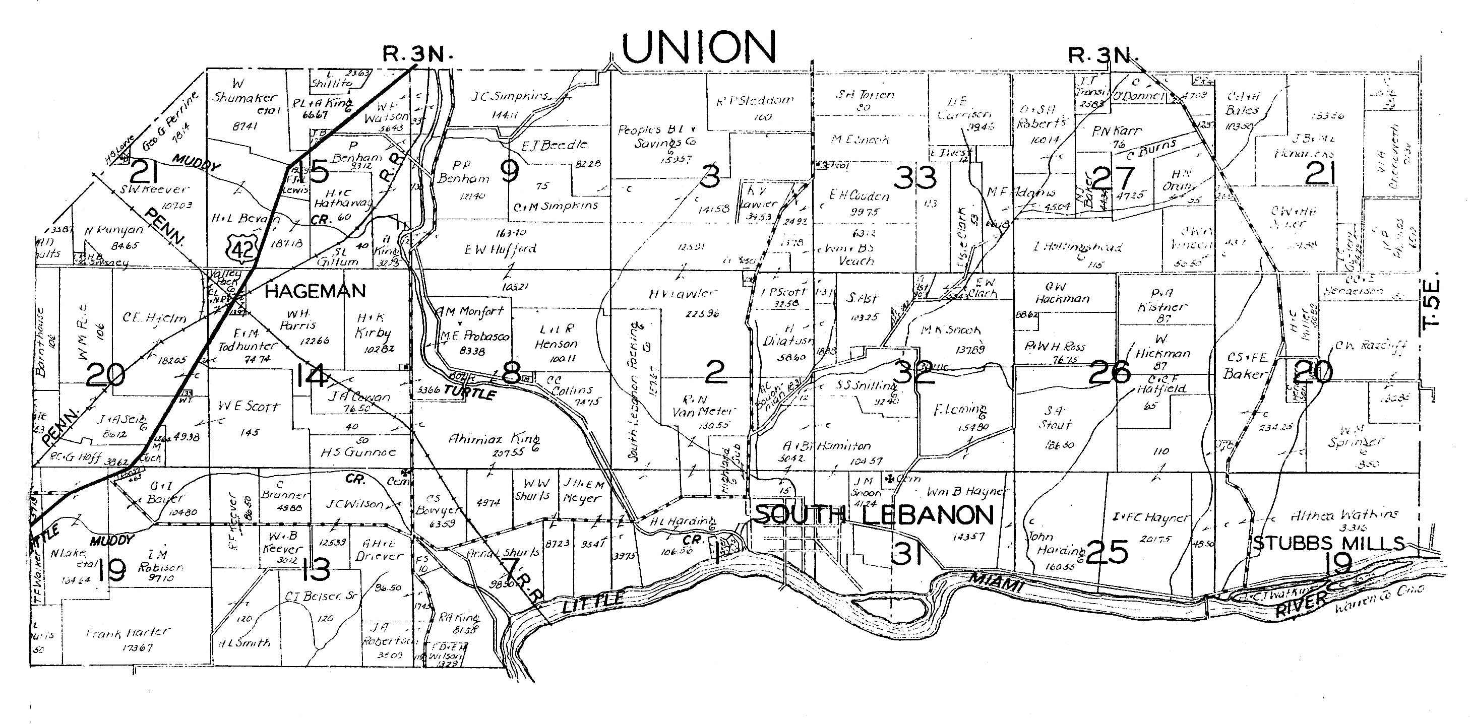
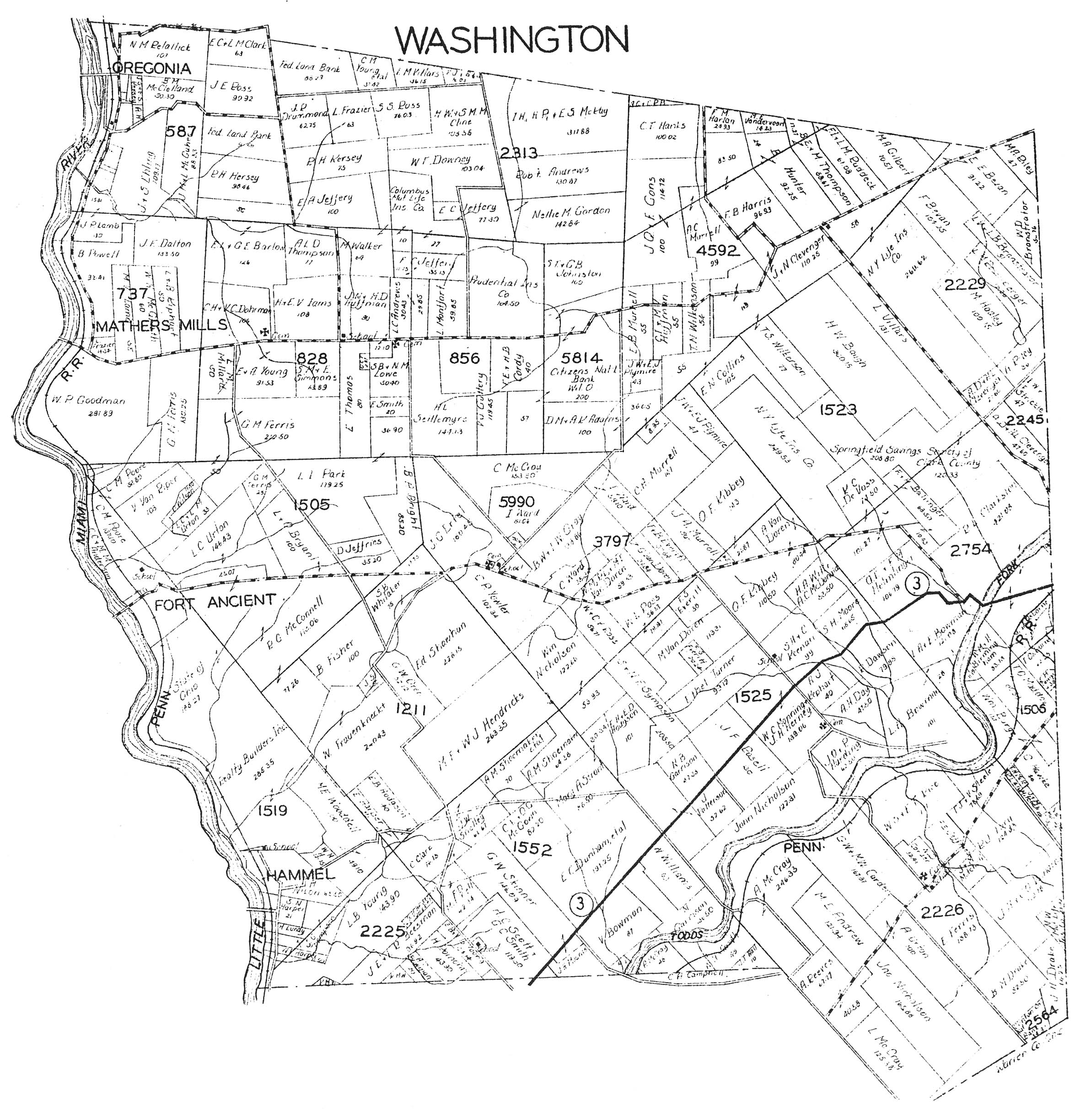
1930 and
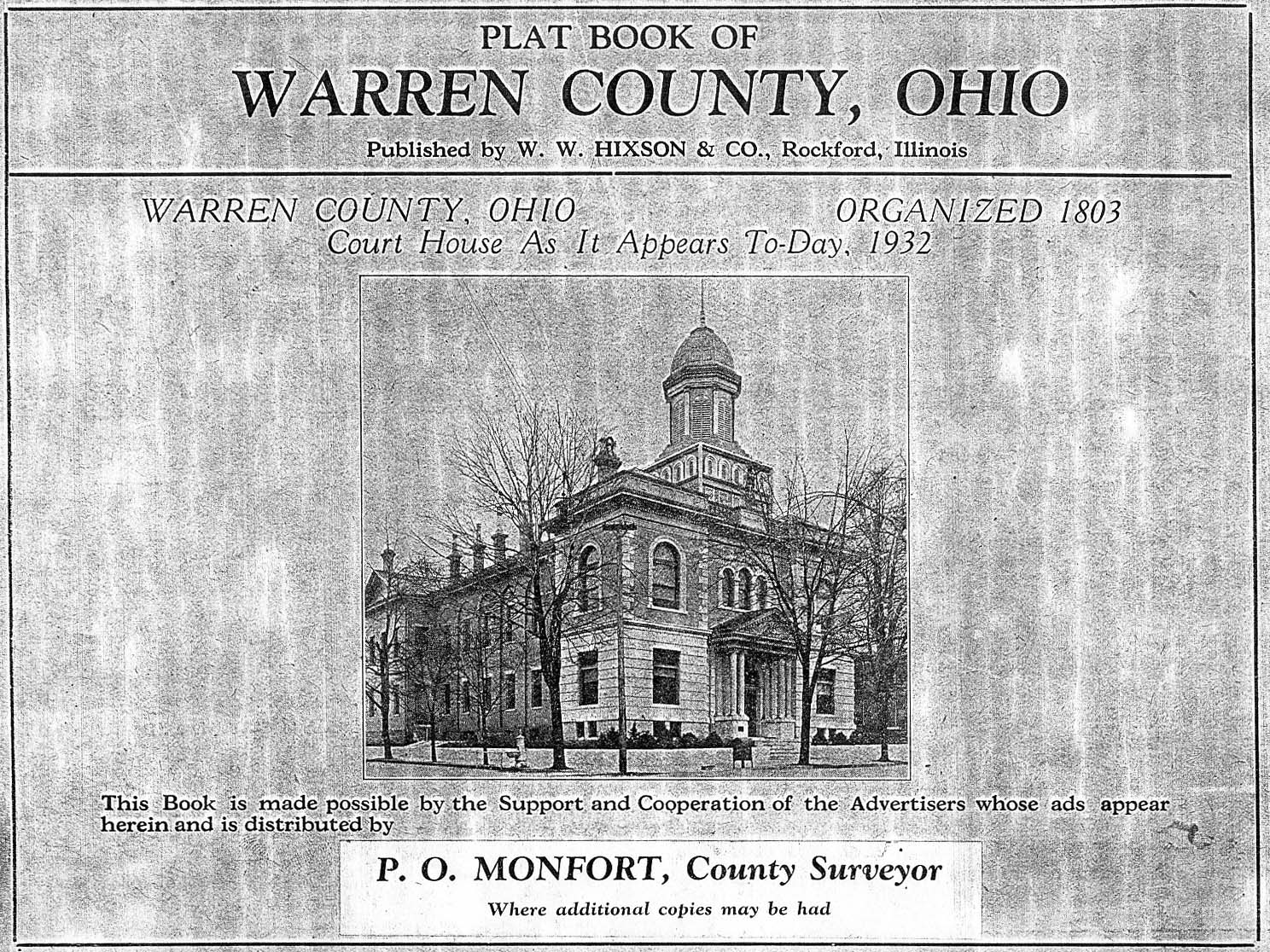
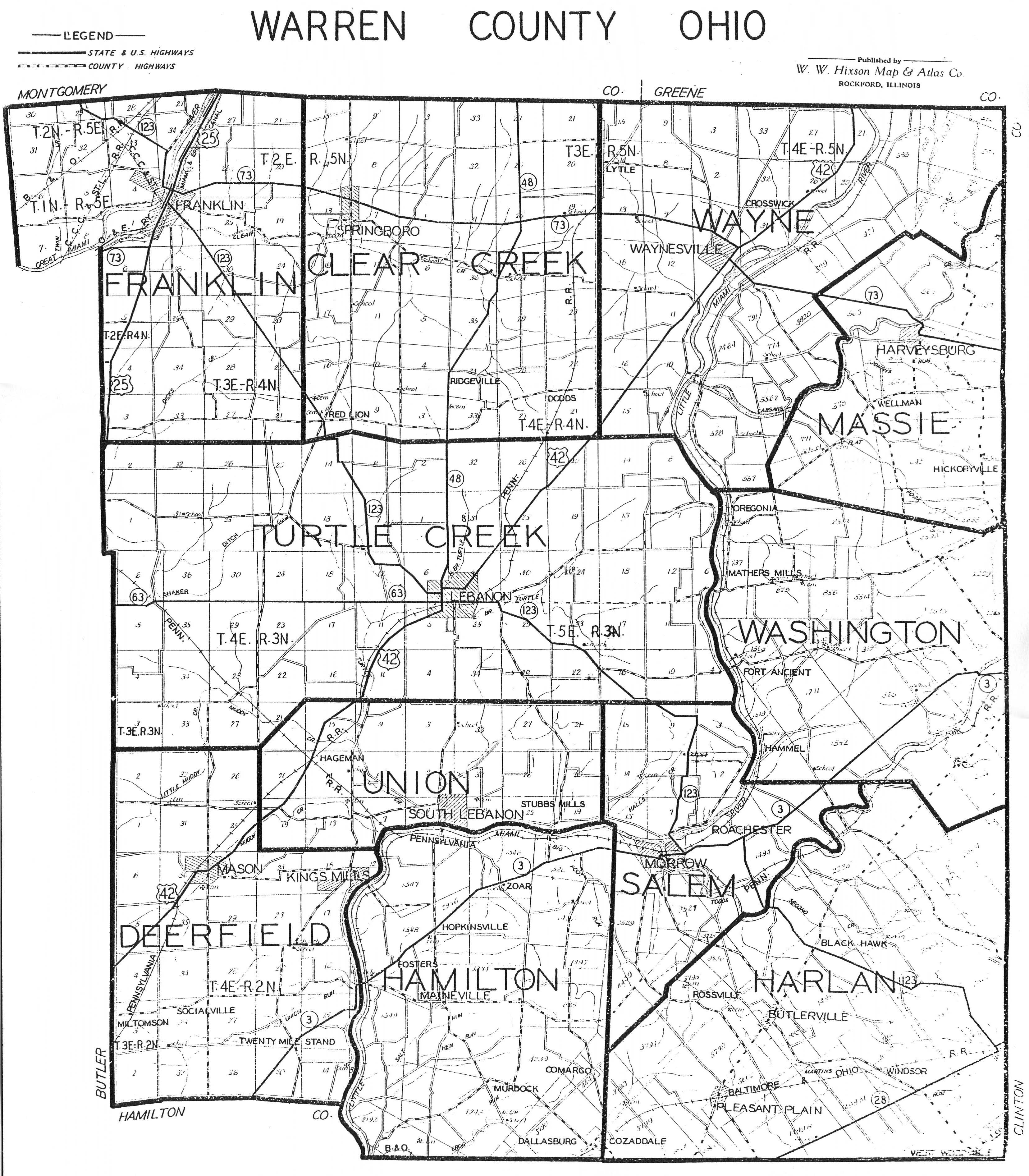
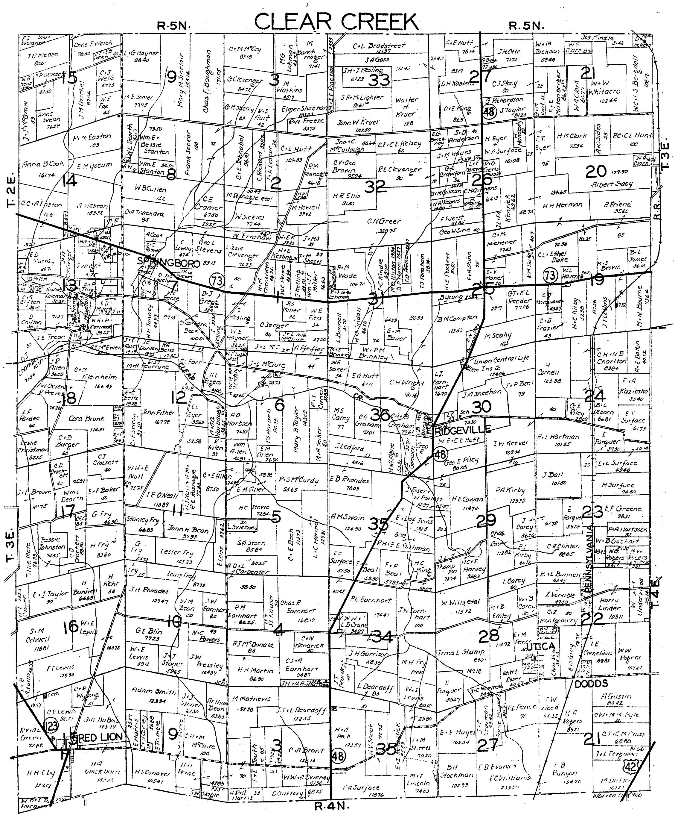
1932 Warren County Plat Book. The Warren County
Engineer has plat books from 1930 and 1932.Images are available below.
WARNING! These
are VERY LARGE FILES!
![]()
Other Warren County Repositories with Atlases
The Mason Public Library has 2 atlases:
Centennial Atlas of Warren County, 1903, by Will S. McKay
New Historical Atlas of Warren County, Ohio, 1875 by L. H. Everts
The Lebanon Public Library has 3 atlases
The Combined Atlas of Warren County, 1875 by L. H. Everts
The Combination Atlas of Warren County, 1875-1903, by L. H. Everts
Complete Atlas of Warren County, 1891 by Frank A. Bone
The Salem Township Library has a good selection of atlases:
The Combination Atlas of Warren County, 1875-1903, by L. H. Everts
Atlas Map of Montgomery County, Ohio, 1875 by L. H. Everts
Atlas of Cincinnati & Hamilton County, Ohio, 1869 by C. O. Titus
Atlas of Clinton County, Ohio 1876 by Lake, Griffing & Stevenson
![]()
©2002-2010 Warren County Genealogical Society
For Non-commercial Use Only
This page was last updated on
01 December 2011
![]()